Hydrogeology
What WE Do
Taylor GeoServices (TGS) understands geologic and hydrogeologic conditions, whether an unconfined saprolite aquifer, a stratified coastal plain aquifer, or a complex bedrock aquifer. TGS has characterized the hydrogeology of sites for remedial action, water supply, and landfill expansion.
Geologic exploration & interpretation
Hydrogeology characterization
Bore hole and Well Logging
Downhole geophysics
Aquifer Testing
Groundwater flow modeling
Case Studies.
Case studies
Solid Waste LANDFILL
Berks County, Pennsylvania
TGS provided geologic and hydrogeologic services associated with gaining an approved 134-acre expansion permit.

TGS conducted detailed studies to define the groundwater flow regime in the complex geology of the Triassic Basin that underlies the site. This work culminated in the development of a numerical model to evaluate the effect of the landfill expansion on groundwater recharge. Due to modeled impacts to a local perennial stream, further studies were completed to evaluate the reduced flow from capping a large area of recharge.
The hydrogeologic expertise of TGS resulted in maintaining airspace for the landfill and ultimately reclaiming three disposal cells that the Pennsylvania Department of Environmental Protection had originally eliminated from the final design permit.

INDUSTRIAL WASTE LANDFILL
New Castle County, Delaware
This assessment included the drilling of additional test borings, installation of background characterization wells and piezometers and the utilization of cone penetrometer for geotechnical analysis of deep Cretaceous age sediments found beneath the site. TGS then compiled the geologic and hydrogeologic data obtained from this investigation plus previous studies conducted by others into a permit application document for submission to the Delaware Department of Natural Resources and Environmental Control (DNREC). Subsequently TGS developed the comprehensive groundwater and surface water sampling and analysis plan for the landfill.

Pennsylvania Underground Storage
Tank Indemnification Fund
Hamlin, Wayne County, Pennsylvania
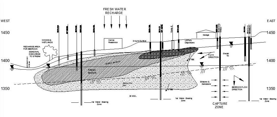
Taylor GeoServices (TGS) staff completed a comprehensive hydrogeogologic site characterization and remedial action associated with a leaking underground storage tank. The facility operated as a gasoline service station from 1975 to 1998. Obvious contamination observed during the removal of the UST system 1999 triggered a site characterization, interim remedial action and final remediation under the Pennsylvania storage tank regulations.
The site is situated over top of glacial till consisting of a heterogeneous mixture of clay, sand, gravel, cobbles and localized boulders. Relatively flat lying sedimentary layers of shale, siltstone, sandstone and conglomerate associated with the Catskill Formation, underlies the glacial deposit around 50 feet below the ground surface.

Characterization efforts included a thorough review of background documentation, site and outcrop mapping, monitoring wells, nested monitoring wells, soil sampling, groundwater sampling, aquifer testing, domestic water well sampling, surface water sampling, fate and transport modeling, vapor intrusion screening, ecological and receptor screening, interim soil excavation, remediation pilot testing, remedial action screening, and final remediation implementation.
The hydrocarbon plume followed the shallow groundwater flow direction. However, a steep vertical gradient between the glacial till aquifer and the bedrock aquifer, along with recharge induction, caused MTBE to dive into the bedrock. In bedrock, MTBE spread through interconnected fractures concurrent with the regional flow regime. MTBE was also drawn toward local on-lot water supply wells, including wells located outside the plume migration pathway as a result of overlapping cones of depression. TGS’ sound understanding of the complex hydrogeologic conditions allowed an optimized groundwater remediation strategy to obtain site closure with a limited budget.
Location
Longitude: 75° 24.23'W
Elevation: 380+/- feet msl
